Know Everything About NavIC: India’s Own GPS System
NavIC, short for Navigation with Indian Constellation, is also known as IRNSS Indian Regional Navigational Satellite System is India’s very own satellite navigation system developed by the Indian Space Research Organisation (ISRO). NavIC consists of seven satellites (IRNSS-1B, IRNSS-1C, IRNSS-1D, IRNSS-1E, IRNSS- 1F, IRNSS-1G, IRNSS-1I) orbiting Earth to provide accurate
NavIC, short for Navigation with Indian Constellation, is also known as IRNSS Indian Regional Navigational Satellite System is India’s very own satellite navigation system developed by the Indian Space Research Organisation (ISRO).
NavIC consists of seven satellites (IRNSS-1B, IRNSS-1C, IRNSS-1D, IRNSS-1E, IRNSS- 1F, IRNSS-1G, IRNSS-1I) orbiting Earth to provide accurate positioning and timing information.
These satellites work together to provide continuous coverage over the Indian subcontinent and up to 1,500 kilometres beyond its borders.
The system offers various services such as Standard Positioning Service (SPS) for civilian use, Restricted Service (RS) for authorized users like defence forces, and a Search and Rescue service.
Why NavIC was Developed?
Commonly, we use GPS for tracking, but the main aim of developing and promoting NavIC is to enhance India’s self-reliance in satellite navigation.
The system was created because sometimes in tough situations, we can’t always trust the navigation systems controlled by other countries.
In 1999, for instance, the Indian military sought GPS data as soon as Pakistani troops took position in Kargil. The US government denied India access to its space-based navigation system, which would have provided vital information.
Before, India was aware of the need for an indigenous satellite navigation system, but the Kargil experience made it more apparent. So, in May 2006, the Indian government decided to develop its navigation system to reduce its dependence on foreign systems like GPS or GLONASS.
As a result of NavIC, India has better control over its navigation and timing data, which is important for national security and data integrity.
Also, it not only helps improve transportation, disaster response, and farming but also encourages new ideas and technological growth within the country.
How does NavIC Work?
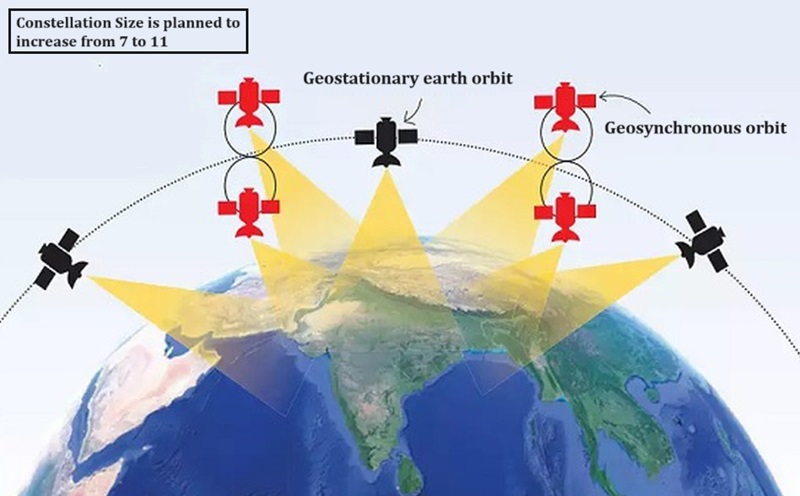
To understand how NavIC works let’s split it into three segments, the space segment, the ground segment, and the user segment.
Space Segment: This part involves satellites in space. The space segment consists of seven satellites three satellites (1C,1F,1G) in geostationary orbits and four satellites (1A,1B,1D and 1E) in geosynchronous orbits.
These satellites send signals to the ground.
Ground Segment: Here, we have stations on the ground. These stations collect data and information about navigation. They then send this data up to the satellites. The satellites, in turn, send this information back down to Earth for users to access.
User Segment: This part is all about us, the users! We have devices that pick up the signals sent by the NavIC satellites. With this information, our devices can figure out where we are, help us navigate, and even keep track of time accurately.
Frequency Band used in NavIC
The NavIC system operates on two frequency bands: L5 and S-band.
The satellites IRNSS-1A, 1B, 1C, 1D, 1E, and 1F work on the L5 band, while IRNSS-1G operates on the S-band.
The L5 band (1176.45 MHz) is primarily used for civilian applications, offering improved accuracy and better resistance to signal interference.
On the other hand, the S-band (2492.028 MHz) is utilized for messaging services and satellite-based search and rescue operations.
Features of NavIC
- Navigation: NavIC provides precise positioning information for various applications such as transportation, agriculture, and disaster management.
- Timing: It offers highly accurate timing signals vital for sectors like telecommunications and power grid synchronisation.
- Surveying: NavIC helps in land surveying, mapping, and geodetic data collection with its reliable satellite-based positioning.
- Emergency Services: It supports search and rescue operations by enabling quick and accurate location tracking during emergencies.
- Weather Forecasting: NavIC contributes to meteorological services by providing atmospheric data for improved weather predictions.
Implementation of NavIC in Mobile Handsets

The government wants to make NavIC a must-have feature in smartphones sold in India. They aim to ensure that by January 1, 2025, all 5G phones sold in India support NavIC. For other phones, this requirement extends to December 2025.
The government is talking to phone manufacturers to ensure they include the Indian navigation system in their phones right from the start.
Major Challenges Faced by NavIC
NavIC, India’s navigation system, faces some significant challenges that hold it back from being widely adopted. One major issue is its limited coverage area compared to other navigation systems like GPS. This means it might not work well in some places.
Another problem is that NavIC doesn’t have as many satellites in its constellation as other systems do. This affects its accuracy and reliability.
Many people aren’t familiar with NavIC or don’t trust it as much as other systems, which means they might not use it even if it’s available.
Also, NavIC isn’t supported by most smartphones because it uses a frequency band called L5, which is more complicated and expensive to implement. Most phones use a different band called L1, which is easier and cheaper.
However, experts believe that if ISRO launches satellites for the L1 band, it would make it much easier to use NavIC on all phones. This could help NavIC become a more effective and popular navigation option.
Name of the Navigation System in Other Countries
US: GPS (Global Positioning System) World’s most used GPS, operational since 1978. It is a Constellation of 32 satellites.
Europe: Galileo – It became operational in 2016, with a constellation of 30 satellites.
Russia: GLONASS It provides global coverage. It has a total of 26 satellites.
China: BeiDou – It provides regional coverage of the Asia-Pacific region and plans to provide global coverage by 2020. It has a total of 35 satellites.
Japan: QZSS (Quasi-Zenith satellite system) is a regional satellite system covering Japan and the Asia-Oceania region. It has a total of 4 satellites, 7 are planned.
Conclusion
NavIC, India’s satellite navigation system, is a big deal for the country. It means that India doesn’t have to rely on other countries’ systems for navigation anymore. Instead, it has a group of satellites that can pinpoint locations in India and beyond its borders.
Even though it is still being worked on and improved, it’s already becoming more popular. You can see it in smartphones and in various industries where precise location information is crucial.
For regular residents like us, NavIC means we can use our own country’s navigation system through apps on our phones or other connected devices. And there’s more to come – it is getting even better, with plans to be more accurate and available to even more people in the future.
Stay Updated and Follow us!
If you want to stay updated with the latest compliance news, updates, amendments and so on then we have various options for you to stay up-to-date.
Subscribe to our Free Monthly Newsletter, and WhatsApp Channel or watch our Publication Space to stay ahead with the latest regulations and notifications without spending a dime!